On 31 January 2025, the Department for Environment, Food and Rural Affairs (DEFRA) launched England’s Land Use Framework, aiming to balance farming, nature conservation, housing, and renewable energy while meeting climate and biodiversity goals. The 12-week consultation period has now ended, with the British Society of Soil Science (BSSS) among those who submitted a response to help shape the final framework, due for publication later this year.
What is the Land Use Framework?
England’s land is under growing pressure from the climate and biodiversity crises, extreme weather, global shocks, and changing consumer and policy demands. In response, Defra has launched a consultation to kickstart a national conversation about how land can best deliver on the country’s goals for clean energy, food security, climate targets, and sustainable growth.
The Government’s vision includes:
- Making space for nature, water, and emissions cuts to meet legal climate and environment commitments.
- Supporting resilient, sustainable food production that secures farmers’ futures.
- Delivering infrastructure and housing—including 1.5 million new homes—with smarter, strategic planning.
- Building the foundations for long-term economic growth by investing in natural capital.
- Co-creating plans with land managers, businesses, and communities to ensure land use changes bring both economic and environmental benefits.
DEFRA has outlined indicative projections for how England’s agricultural land use could change by 2050. The figures suggest that 81% would involve changes in management practices, 10% would shift towards land sharing (including 5% substantive land use change, 4% a mix of environmental and farming use, and 1% minor changes), while 9% would move away from farming entirely.
The British Society of Soil Science’s (BSSS) response
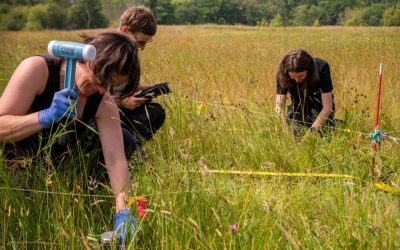
The development of England’s Land Use Framework is a welcome step in addressing the growing pressures on our limited land supply. Central to this is soil health: soils are vital carbon stores, support essential ecosystem services, and sustain biodiversity. Yet, years of intensive agriculture have degraded UK soils. Protecting and restoring them is crucial to building climate resilience, securing our food systems, and supporting nature recovery.
While BSSS welcomed the use of Cranfield University’s LandIS soil data to support Principle 3 in the Framework (playing to land strengths) in assessing suitability for habitat and peatland restoration, and could also enhance Principle 2 (Multifunctional Land) and Principle 4 (Decisions fit for the long term.
BSSS has outlined the below key considerations that form the basis of our official consultation response.
1) High quality data
The most comprehensive collection of inherent soil data in England comes from the national soil survey funded by MAFF over 60 years, culminating in a 1:250,000 scale map in the mid-1980s. The programme ended before completing detailed spatial mapping. This historical data, held in the LandIS database at Cranfield under a Defra agreement, remains relevant.
Underpinning soil data for England and Wales should be made freely available, as in Scotland. The current lack of >1:250,000 scale data is a barrier to effective land use planning. Open access to national soil datasets should be enabled and funded, with a proposed “Centre for Solis” (please see next point below) as a delivery mechanism.
Additionally, the methodologies behind the current ALC system were developed over 35 years ago. Given its role in DEFRA’s Land Use Change Framework, its effectiveness should be reviewed and updated if needed. Countries like Germany, Switzerland, and the Czech Republic use Soil Quality Indicators (SQUID) to reflect a broader range of soil functions, which could be explored in England. The ALC’s main limitation is its focus on agriculture, neglecting other critical soil functions. A technical review of the methodology and underlying datasets is necessary.
2) A National Centre for Soils
Other soil datasets are held by CEH and various organisations, but the ad hoc development since 1987 has limited their usefulness.
Much of the relevant soil data is currently held across different sectors, including the planning sector, with many different organisations holding soil data—the benefits of integrating them are significant. A “National Centre for Soil Resources” should be created, complementing existing NERC centres, to collate, standardise and share all national soil data via accessible tools and apps. Climate change impacts should also be considered—where soils need strengthening, and future crop suitability, especially as drought increases in eastern regions.
3) Training
There is a well-evidenced national shortage of experienced field soil surveyors pedologists with the foundational skills required for soil resource surveys. While BSSS delivers short CPD (see Professional Competency) these cannot replace formal training. At Lancaster and other universities (Aberdeen, Bangor, Newcastle, Reading), pedology and soil description are taught at UG and MSc levels, with a new industry-led Soil Apprenticeship recently launched at Cranfield University. The closure of the national Soil Survey program (in 1986) and lack of student numbers to make soil-focused courses viable. As such, we recommend:
- The introduction of a register of Certified ALC Surveyors, based on BSSS competency documents, managed by Natural England.
- Support BSSS to develop CPD programmes with multiple delivery partners to meet the urgent requirement UK PLC needs to reverse the serious national shortage of soil scientists. Investment is needed to improve ALC survey standards by supporting professional training and certification beyond short introductory courses to avoid reports of poor quality ALC surveys.